
Pittsburgh Zoning Map - North Side Commercial Parking Prohibited Area
By Carolyn Ristau

Introduction
Pittsburgh’s interactive zoning map includes many layers besides the zoning districts, most of which relate to requirements within or adjacent to the zoning code. For an overview on how to use the interactive zoning map, see our introductory post.
To select different layers, click the stack of paper in the upper right corner. The layers available are listed below. Today’s post features the North Side Commercial Parking Area layer, pictured above and in bold text below.
Zoning
Zoning Districts
Zoning Districts Outlines
Zoning Max. Height Overlay
Height Reduction Zone Overlay
1500’ Major Transit Buffer
Parking Reduction Areas
North Side Commercial Parking Prohibited Area
Baum Centre Zoning Overlay
Inclusionary Housing Overlay District
RCO (Registered Community Organization) Areas
City Divisions
DPW Divisions
Neighborhoods
Council Districts 2012
Council Districts 2022 (Current)
Wards
Historic Preservation
Mexican War Street Historic Boundary
Individual City-Designated Properties
Pittsburgh City Historic Districts
Environment
RIV Riparian Buffer (125 Feet)
Stormwater Riparian Buffer
Floodplain Areas
Landslide Prone
Potential Steep Slopes Overlay Area
Undermined Areas
Addresses
Allegheny County
City Boundaries
Imagery 2021
The North Side Commercial Parking Area

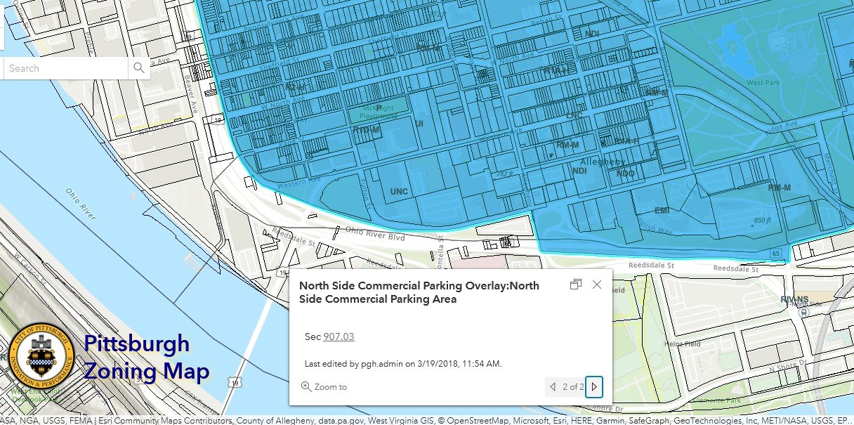

Overview
This layer of the interactive zoning map shows the boundaries of the North Side Commercial Parking Overlay District. When this layer is clicked, the pop-up box confirms that the point clicked is within the boundaries of the area and links to the zoning code section that discusses the North Side Commercial Parking Overlay District regulations, which are copied below.
Relationship with Zoning
The regulations for the North Side Commercial Parking Area Overlay District are in the Development Overlay Districts Chapter of the Zoning Code (Chapter 907).
907.03. - NSCPO, North Side Commercial Parking Area Overlay District.
907.03.A Intent
The intent of the NSCPO District is to prohibit the installation of commercial parking areas as defined under Sec. 911.02 on vacant lots.
907.03.B Application
When an Occupancy Permit Application is filed for zoning approval of a commercial parking area on property located within a NSCPO District, the Zoning Administrator shall disapprove the application.
In other words, an application for a new primary use as commercial parking on a currently vacant lot is likely to be denied when located in this overlay.
Conclusion
If your project is for a new commercial parking area on a vacant lot, check Pittsburgh’s interactive zoning map to see if the site is within the boundaries of the North Side Commercial Parking Area. If it is, either consider a different site to put the commercial parking use or consider a different use for the site. When neither of these options is compatible with the project needs, a third option is to request a variance from the Zoning Board of Adjustment, though there are no guarantees for the outcome.